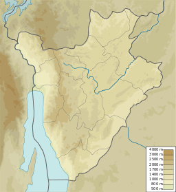
Lake Gacamirindi
| Lake Gacamirindi | |
|---|---|
| French: Lac Gacamirindi | |
| Location | Kirundo Province of Burundi |
| Coordinates | 2°27′00″S 30°00′00″E / 2.45000°S 30.00000°E |
Lake Gacamirindi (French: Lac Gacamirindi, 2°27′00″S 30°00′00″E / 2.45000°S 30.00000°E), or Lake Gacamirinda, is a lake in the Kirundo Province of Burundi.
Location[edit]
Lake Gacamirindi is in the Commune of Bugabira, Kirundo Province.[1] The lake covers an area of 250 hectares (620 acres), and is set between hills with fairly steep slopes.[2] It is surrounded by the densely populated collines of Kiri and Nyakarama.[3] In the past the lake merged into a marshy area beside the Akanyaru River.[2] Now banana and sorghum are cultivated both upstream and downstream of the lake.[4] Lake Gacamirindi would normally be fed by the waters of the Akanyaru river, but as of 2011 was separated from this river by farmland and had become a small pond of a few hectares.[2] Typha domingensis forms a very narrow belt around this pond, separating the crops and the water.[5]
Lake Gacamirindi dried up in 2004, a period of normal precipitation.[6] Lake Narungazi and Lake Nagitamo now supply water to Lake Gacamirindi through an canal connecting the lakes through the Rugege marsh.[7] There is a risk that this canal will lower the water level of Lake Rwihinda, particularly during periods of drought, when water no longer flows from the Akanyaru River to Lake Rwihinda.[8]
Protection[edit]
|n 2001 there was an attempt to create a buffer zone between the lake and the cultivated land, but it was not respected.[7] Lake Gacamirindi is now in the western part of the Paysage aquatique protégé du Nord (Protected Aquatic Landscape of the North), created in 2011.[9] It is protected as an "Integral Zone", where human presence will be phased out. A buffer zone, or belt of land at least 50 metres (160 ft) wide, will be established around the lake.[10]
References[edit]
- ^ Way: Lac Gacamirinda.
- ^ a b c Décret n°100-114.
- ^ Nzigidahera, Fofo & Misigaro 2005, p. 40.
- ^ Nzigidahera, Fofo & Misigaro 2005, p. 43.
- ^ Nzigidahera, Fofo & Misigaro 2005, p. 13.
- ^ Nzigidahera, Fofo & Misigaro 2005, p. 29.
- ^ a b Nzigidahera, Fofo & Misigaro 2005, p. 44.
- ^ Nzigidahera, Fofo & Misigaro 2005, p. 62.
- ^ Fiche descriptive ... Ramsar, p. 6.
- ^ Kagera TAMP FAO.
Sources[edit]
- Décret n°100-114 du 12 avril 2011 portant délimitation du paysage aquatique protégé du nord., Food and Agriculture Organization, 12 April 2011, retrieved 9 June 2024
- Fiche descriptive sur les zones humides Ramsar (FDR) (PDF) (in French), 14 March 2013, retrieved 9 June 2024
- Kagera TAMP - Bugesera aquatic landscapes endowed with a management plan, Kirundo province, Burundi: FAO, 8 July 2011, retrieved 9 June 2024
- Nzigidahera, Benoît; Fofo, Alphonse; Misigaro, Apollinaire (August 2005), Paysage Aquatique Protege du Nord du Burundi – Etude D'identification (PDF) (in French), retrieved 9 June 2024
- "Way: Lac Gacamirinda (25469567)", OpenStreetMap, retrieved 2024-06-12

